SAT4GAIA
The SAT4GAIA project will create Greece’s national Earth monitoring service under the National Microsatellite Program. It will turn satellite data…
SAT4ΦOREST
The SAT4ΦOREST project aims to develop an integrated satellite-based monitoring service for the protection and sustainable management of Greece’s forests.…
Hellenic Space Dawn
Hellenic Space Dawn: Selene & Helios
Geosystems Hellas (GSH), together with EMTEC Space P.C., ISD S.A., HERON Engineering, LEO Photonics,…
European Sensor Systems S.A
European Sensor Systems S.A.: Supply of software in the context of the development of an observatory system for integrated…
Technological Educational Institute of Kavala
2012-13 : Technological Educational Institute of Kavala: Supply of equipment and software and creation of a web content management system…
SmartPlant Technology for Megalopolis Coal Mine
In 2012, GEOSYSTEMS HELLAS implemented SmartPlant technology for the Megalopolis coal mine on behalf of PPC – Public Power Corporation.…
Fire Disaster Mapping in Dadia Forest Natura Area (WWF)
2011 – Fire Disaster Mapping in Dadia Forest Natura Area
In 2011, GEOSYSTEMS HELLAS conducted fire disaster mapping for the…
OTE group
2010 : The company provided to OTE group, department Fixed Access Geographical Information System & Services DevOps, Hexagon Geospatial…
DRIC-DEFKALION
DRIC-DEFKALION: GSH leveraged its expertise in GIS, remote sensing, and disaster risk management to showcase solutions, identify synergies, and contribute…
OPEKEPE
2021: OPEKEPE: Upgrade of the existing Hexagon Geospatial software of the Payment and Control Agency for Guidance and Guarantee Community…
EOMALL
Through its participation, GEOSYSTEMS HELLAS showcases its expertise, services, and innovative solutions to a broader European audience, supporting the visibility,…
LUCAS
The LUCAS 2025 project is focused on creating an updated, harmonized, and high-quality dataset of land use and land cover…
Hellenic Military Geographical Service (HMGS): GSH, in collaboration with COSMOS
2024 – Hellenic Military Geographical Service (HMGS): GEOSYSTEMS HELLAS (GSH), in collaboration with Cosmos Business Systems A.E.B.E. , is implementing…
Austrian Archaeological Institute
2021: Austrian Archaeological Institute: 3D mapping of the wider area of the archeological site of Aigeira. More specifically, 3D imaging…
E65 Motorway Topographic Survey Using LiDAR and Aerial Photography
Geosystems Hellas contributed to the topographic background survey for the Central Greece Motorway E65, using a LiDAR system in parallel…
Projects in the Republic of Moldova
2017-2018 : The company conducted LiDAR and 10 cm resolution RGB aerial mapping for road construction projects in the Republic…
RGBNIR airborne Stereo Imagery Coverage
2015 : 10cm RGBNIR airborne Stereo Imagery Coverage and processes for the Integrated Information System for the Promotion of Cultural…
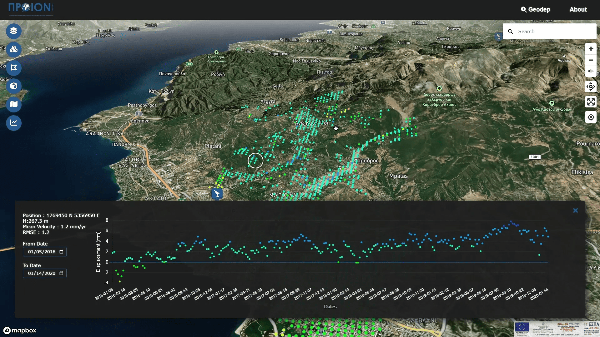
InSAR Time Series
2014 : Geological Survey Department: InSAR Time Series with Atmospheric Estimation Model (InSAR TS + AEM), Pafos District, time series…
Department of Lands and Surveys, Cyprus Ministry of Interior
2013 : The company supplied the Department of Lands and Surveys, Cyprus Ministry of Interior, with Hexagon Geospatial Photogrammetry Lab…
PROTERGIA
2011: Digital Terrain Model (DTM) country coverage for PROTERGIA , delivering high-resolution elevation data for various applications. Utilizing advanced technologies…
Digital Technical Map of Santorini Island | Geosystems Hellas
2014 :Development of a Digital Technical Map for the Island of Santorini by Geosystems Hellas with Universita degli…
Bathymetric GIS Maps for Greece & the Mediterranean | Fisheries Monitoring Center
Geosystems Hellas contributed to the development of bathymetric GIS maps for Greece and the Mediterranean region, supporting the creation of…
LUCAS
The LUCAS 2025 project is focused on creating an updated, harmonized, and high-quality dataset of land use and land cover…
Hellenic Military Geographical Service (HMGS): GSH, in collaboration with COSMOS
2024 – Hellenic Military Geographical Service (HMGS): GEOSYSTEMS HELLAS (GSH), in collaboration with Cosmos Business Systems A.E.B.E. , is implementing…
Austrian Archaeological Institute
2021: Austrian Archaeological Institute: 3D mapping of the wider area of the archeological site of Aigeira. More specifically, 3D imaging…
E65 Motorway Topographic Survey Using LiDAR and Aerial Photography
Geosystems Hellas contributed to the topographic background survey for the Central Greece Motorway E65, using a LiDAR system in parallel…
Projects in the Republic of Moldova
2017-2018 : The company conducted LiDAR and 10 cm resolution RGB aerial mapping for road construction projects in the Republic…
RGBNIR airborne Stereo Imagery Coverage
2015 : 10cm RGBNIR airborne Stereo Imagery Coverage and processes for the Integrated Information System for the Promotion of Cultural…
InSAR Time Series
2014 : Geological Survey Department: InSAR Time Series with Atmospheric Estimation Model (InSAR TS + AEM), Pafos District, time series…
Department of Lands and Surveys, Cyprus Ministry of Interior
2013 : The company supplied the Department of Lands and Surveys, Cyprus Ministry of Interior, with Hexagon Geospatial Photogrammetry Lab…
PROTERGIA
2011: Digital Terrain Model (DTM) country coverage for PROTERGIA , delivering high-resolution elevation data for various applications. Utilizing advanced technologies…