
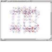
The “Golden Twins” project under ESA’s InCubed program, aims to establish a system-agnostic, multi-mission hosting Earth Observation (EO) platform addressing the unique challenges of Greece’s islands. Focused on forest fire…

The NeAIxt project aims to help Europe lead the development and industrialization of key Edge AI technologies by combining advanced microelectronics, embedded artificial intelligence, and security.
Addressing critical challenges such as population displacement due to conflicts, exacerbated by factors like climate change, extreme weather events, food shortages, and poverty, remains paramount.
Coastal regions are considered pivotal for socio-economic activities facing heightened vulnerability to Climate Change (CC). The imperative for CC adaptation in coastal zones is evident and is expected to be…
The EU has experienced a surge in fixed border surveillance solutions, including physical barriers, now covering 13% of its external land borders. The BorderForce project addresses evolving threats by enhancing…
The TRIQUETRA project aims at creating an evidence-based assessment platform that allows precise risk stratification, and also creates a database of available mitigation measures and strategies, acting as a Decision…

The project aims to detect the pre-visual stages of infection of olive trees affected by the bacterium Xylella fastidiosa (Xf) using satellite data and Remote Sensing technics. With the use…
The present project proposes an application aiming at the improved quality of potato production through more efficient absorption of nutrients, a pro-environmental management of important fungal pathogens ofthe crop by…
Urban areas are currently facing significant new and/or aggravated existing challenges due to the impacts of climate change, including increased frequency and intensity of extreme weather events, urban greenness loss,…
Read more by clicking on the image

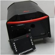
Leica DSW700V Digital Scanning Workstations The World's Fastest Precision Aerial Film Scanner General Description The Leica DSW700V Digital Scanning Workstation is a photogrammetric scanner, capable of scanning aerial…
Leica MissionPro software offers «state of the art true 3D mission planning» solutions.
Leica FPES software offers advanced διαθέτει ανεπτυγμένη functionality for flight plans of RC30, ADS40, ADS80, και LIDAR ALS50, ALS60, ALS70 sensors but also for frame, line cameras or on/off sensors.
Leica IPAS Freebird software contribute to flight economy and facilitate GNSS-IMU operations.
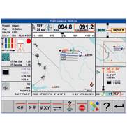
Leica FCMS & Sensor Control Management System software performs a series of functions such as planning, guidance and flight monitoring for a large number of sensors.
The fastest post-flight processing software.
ORIMA Orientation Management της Leica Geosystems software is a modern software for orientations aerial triangulations. It's fully compatible with IMAGINE photogrammetry and ImageStation software.
For corridor surface coverage, the Leica ALS Corridor Mapper can ideally cover low-rise & road applications.