Skip to content
Skip to footer
Who We Are
Company Profile
Company profile
Key Clients & Industries
History
Memberships
Our People
Partners & Associates
Careers
Products
Satellite Imagery
Vessel Spot
Patented Triangle Reflector
Hexagon SIG
Hexagon Safety, Infrastructure & Geospatial
Remote Sensing
ERDAS IMAGINE
ATCOR Workflow for ERDAS IMAGINE | Atmospheric Correction Software
IMAGINE NoClouds
Sentinel Made Simple
ERDAS IMAGINE Add-ons
ER Mapper
Photogrammetry
IMAGINE PHOTOGRAMMETRY
ImageStation
ERDAS Extensions for ArcGIS
GIS and Mapping
GEOMEDIA
GeoMedia Add-ons
GEOMEDIA SMART CLIENT
Web GIS
GEOMEDIA WebMap
GEOSPATIAL Portal
GEOSPATIAL SDI
Data Management
ERDAS APOLLO
ECW Compression
GeoCompressor
Geospatial Platforms
Luciad Portfolio
M.App Enterprise
Leica Airborne Solutions
Airborne Sensor
Leica HawkEye-5 Bathymetric LiDAR Sensor
Leica Chiroptera-5 Bathymetric & Topographic LiDAR
Leica ContentMapper Airborne Imaging Sensor
Leica CityMapper-2 High-Performance Urban Mapping Sensor
Leica ADS100 Airborne Digital Sensor
Leica TerrainMapper-3 linear-mode LiDAR Sensor
Leica SPL100 Single Photon LiDAR Sensor
Leica CountryMapper Hybrid Airborne Sensor
Leica DMC-4 Airborne Imaging Sensor
Airborne Mapping Software
Leica MissionPro Flight Planning Software
Leica LiDAR Survey Studio
Leica XPro – Post Processing Software
Leica HxMap High-Performance Multisensor Workflow
Leica FlightPro Flight Management & Control System
Scanners
Leica DSW700V
Projects
R&D projects
Commercial projects
Newsroom
News
Publications
Brochures & Media
Newsletter
Contact
Facebook
X-twitter
Instagram
Linkedin
Youtube
Who We Are
Company Profile
Company profile
Key Clients & Industries
History
Memberships
Our People
Partners & Associates
Careers
Products
Satellite Imagery
Vessel Spot
Patented Triangle Reflector
Hexagon SIG
Hexagon Safety, Infrastructure & Geospatial
Remote Sensing
ERDAS IMAGINE
ATCOR Workflow for ERDAS IMAGINE | Atmospheric Correction Software
IMAGINE NoClouds
Sentinel Made Simple
ERDAS IMAGINE Add-ons
ER Mapper
Photogrammetry
IMAGINE PHOTOGRAMMETRY
ImageStation
ERDAS Extensions for ArcGIS
GIS and Mapping
GEOMEDIA
GeoMedia Add-ons
GEOMEDIA SMART CLIENT
Web GIS
GEOMEDIA WebMap
GEOSPATIAL Portal
GEOSPATIAL SDI
Data Management
ERDAS APOLLO
ECW Compression
GeoCompressor
Geospatial Platforms
Luciad Portfolio
M.App Enterprise
Leica Airborne Solutions
Airborne Sensor
Leica HawkEye-5 Bathymetric LiDAR Sensor
Leica Chiroptera-5 Bathymetric & Topographic LiDAR
Leica ContentMapper Airborne Imaging Sensor
Leica CityMapper-2 High-Performance Urban Mapping Sensor
Leica ADS100 Airborne Digital Sensor
Leica TerrainMapper-3 linear-mode LiDAR Sensor
Leica SPL100 Single Photon LiDAR Sensor
Leica CountryMapper Hybrid Airborne Sensor
Leica DMC-4 Airborne Imaging Sensor
Airborne Mapping Software
Leica MissionPro Flight Planning Software
Leica LiDAR Survey Studio
Leica XPro – Post Processing Software
Leica HxMap High-Performance Multisensor Workflow
Leica FlightPro Flight Management & Control System
Scanners
Leica DSW700V
Projects
R&D projects
Commercial projects
Newsroom
News
Publications
Brochures & Media
Newsletter
Contact
Facebook
Instagram
Close
Who We Are
Company Profile
Company profile
Key Clients & Industries
History
Memberships
Our People
Partners & Associates
Careers
Products
Satellite Imagery
Vessel Spot
Patented Triangle Reflector
Hexagon SIG
Hexagon Safety, Infrastructure & Geospatial
Remote Sensing
ERDAS IMAGINE
ATCOR Workflow for ERDAS IMAGINE | Atmospheric Correction Software
IMAGINE NoClouds
Sentinel Made Simple
ERDAS IMAGINE Add-ons
ER Mapper
Photogrammetry
IMAGINE PHOTOGRAMMETRY
ImageStation
ERDAS Extensions for ArcGIS
GIS and Mapping
GEOMEDIA
GeoMedia Add-ons
GEOMEDIA SMART CLIENT
Web GIS
GEOMEDIA WebMap
GEOSPATIAL Portal
GEOSPATIAL SDI
Data Management
ERDAS APOLLO
ECW Compression
GeoCompressor
Geospatial Platforms
Luciad Portfolio
M.App Enterprise
Leica Airborne Solutions
Airborne Sensor
Leica HawkEye-5 Bathymetric LiDAR Sensor
Leica Chiroptera-5 Bathymetric & Topographic LiDAR
Leica ContentMapper Airborne Imaging Sensor
Leica CityMapper-2 High-Performance Urban Mapping Sensor
Leica ADS100 Airborne Digital Sensor
Leica TerrainMapper-3 linear-mode LiDAR Sensor
Leica SPL100 Single Photon LiDAR Sensor
Leica CountryMapper Hybrid Airborne Sensor
Leica DMC-4 Airborne Imaging Sensor
Airborne Mapping Software
Leica MissionPro Flight Planning Software
Leica LiDAR Survey Studio
Leica XPro – Post Processing Software
Leica HxMap High-Performance Multisensor Workflow
Leica FlightPro Flight Management & Control System
Scanners
Leica DSW700V
Projects
R&D projects
Commercial projects
Newsroom
News
Publications
Brochures & Media
Newsletter
Contact
Climate Change & Environment
Urban & Wellbeing
Maritime Awareness
Security & Defense
Civil Protection & Safety
Cultural Heritage
Energy & Utilities
ΝeΑΙxt
The NeAIxt project aims to help Europe lead the development and industrialization of key Edge AI technologies by combining advanced…
Read more
PROION
The purpose of the PROION project is the development of a platform for the continuous monitoring of high-priority infrastructures (public…
Read more
Co-Protect
The CO-PROTECT project aims to strengthen Greece’s role in the field of natural disaster response and climate resilience. At a…
Read more
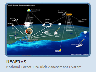
NFOFRAS
The National Forest Fires Risk Assessment System (NFOFRAS) is an ongoing collaborative research program for the development and continuous upgrading…
Read more
Acritas
ACRITAS aimed at the research, design, development and validation of space-based integrated applications for surveillance and monitoring through advanced multi-sensor…
Read more
SPACE 4.0
The SPACE project, as an outcome of the Greek Cooperative Formation of Space Technologies and Applications (Si-Cluster), focuses on earth…
Read more
Supersite
The Greek Supersite aims to advance the understanding and monitoring of one of Europe’s most seismically active regions through long-term…
Read more
Indes Musa
This project aims to develop an integrated monitoring system for ground subsidence and seismic motion in urban areas. The monitoring…
Read more
STABLE Project
The STABLE project developed an IT platform to monitor and forecast risks affecting Europe’s Cultural Heritage. The project focused on…
Read more
Skip to content
Open toolbar
Accessibility Tools
Accessibility Tools
Increase Text
Increase Text
Decrease Text
Decrease Text
Grayscale
Grayscale
High Contrast
High Contrast
Negative Contrast
Negative Contrast
Light Background
Light Background
Links Underline
Links Underline
Readable Font
Readable Font
Reset
Reset