S2GAIA Sentinel-2 Dataset for AI-Driven Land Cover Mapping in Greece
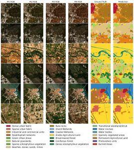
Geosystems Hellas is proud to contribute to S2GAIA, a multi-year and seasonally aware Sentinel-2 dataset developed within the SAT4GAIA project to support AI-driven Land Use and Land Cover (LULC) mapping in Greece.
The S2GAIA Sentinel-2 dataset provides a structured Earth Observation resource for the development, training and evaluation of advanced GeoAI and deep-learning models.
A Multi-Year Earth Observation Dataset for Greece
S2GAIA includes 34,030 annotated Sentinel-2 image patches covering the period from 2017 to 2024.
The dataset incorporates:
Four seasonal observations per year
A detailed 22-class Land Use and Land Cover taxonomy
Multi-temporal Sentinel-2 satellite imagery
Annotated data suitable for AI and deep-learning applications
By incorporating seasonal information across multiple years, the dataset enables AI models to better identify changes in vegetation, land characteristics and land-use patterns.
Supporting GeoAI and Land Monitoring Applications
The S2GAIA dataset provides a strong foundation for the development of GeoAI applications for environmental and land monitoring.
Its multi-year and multi-season structure can support applications related to:
Land Use and Land Cover mapping
Environmental monitoring
Spatial and urban planning
Natural resource management
Change detection
AI-based Earth Observation analysis
Data-driven decision-making
The dataset contributes to the development of more robust and scalable methods for transforming satellite imagery into actionable geospatial information.
Strengthening Greece’s Earth Observation Capabilities
S2GAIA is one of the scientific outcomes developed within SAT4GAIA, which focuses on strengthening the use of satellite data and advanced geospatial technologies for national-scale monitoring and decision support.
Following the successful completion of its initial phase, SAT4GAIA is continuing through a new implementation phase. The new phase will build on the results already achieved and further strengthen Greece’s national Earth monitoring capabilities.
It will also support the continued development and operational use of satellite-based geospatial services, helping public authorities and other stakeholders access reliable Earth Observation information for evidence-based decision-making.
Through SAT4GAIA and outcomes such as the S2GAIA Sentinel-2 dataset, Geosystems Hellas continues to advance the use of Earth Observation, GeoAI and geospatial intelligence for sustainable and data-driven decision-making in Greece.