

3D Mapping and LiDAR Surveying of the Sanctuary of Zeus at Mount Lykaion
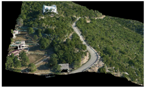
In 2017, GEOSYSTEMS HELLAS collaborated with the University of Arizona on the 3D mapping and aerial LiDAR surveying of the Sanctuary of Zeus at Mount Lykaion, Greece, an important archaeological and cultural heritage site. The project focused on producing high-resolution geospatial data and detailed three-dimensional representations of the archaeological landscape to support archaeological research, historical documentation and cultural heritage preservation.
The study covered an extensive area of 117.85 km², combining advanced Airborne Laser Scanning (ALS/LiDAR) technology with high-resolution RGB aerial imagery to capture accurate terrain information across a large and complex archaeological landscape.
Advanced Airborne LiDAR and High-Resolution Aerial Mapping
The geometric documentation of archaeological sites presents significant challenges due to complex terrain, irregular structures and limited accessibility. Traditional terrestrial surveying methods can be time-consuming and costly, particularly when applied to extensive archaeological landscapes.
To address these challenges, the project integrated airborne LiDAR scanning and aerial photogrammetry, enabling efficient collection of detailed geospatial information across the study area.
LiDAR point clouds and high-resolution RGB aerial images were acquired simultaneously, providing complementary datasets for accurate 3D mapping and spatial analysis.
The collected LiDAR data underwent strip alignment and georeferencing using Ground Control Points (GCPs) and Check Points (CPs) to ensure spatial accuracy and consistency.
3D Point Cloud Processing and Digital Terrain Modeling
Following data acquisition, the LiDAR point clouds were processed and classified to identify bare-earth points and generate a detailed Digital Terrain Model (DTM) of the archaeological landscape.
A fully automated aerial triangulation process was performed using GPS/INS data to accurately position and align the aerial imagery.
The processed datasets enabled the production of several high-resolution geospatial deliverables, including:
Classified ALS/LiDAR point clouds, providing detailed three-dimensional information about the surveyed landscape.
Digital Terrain Model (DTM), generated from classified bare-earth LiDAR points.
High-resolution orthophotos, with a Ground Sample Distance (GSD) of 10 cm.
Colorized 3D LiDAR point clouds, integrating LiDAR measurements with RGB information derived from the orthophotos.
Georeferenced aerial imagery, supporting archaeological mapping, spatial interpretation and landscape analysis.
The LiDAR point density varied across the surveyed area depending on the overlap between adjacent airborne scanning strips.
Supporting Archaeological Research and Cultural Heritage Preservation
The integration of airborne LiDAR technology, aerial photogrammetry and 3D geospatial data processing provided a comprehensive digital representation of the Sanctuary of Zeus at Mount Lykaion and its surrounding landscape.
The resulting geospatial datasets offer valuable resources for archaeological documentation, topographic analysis, historical landscape interpretation and future research activities.
The collaboration with the University of Arizona demonstrates the effectiveness of combining advanced remote sensing technologies with high-resolution aerial imagery for the 3D geometric documentation of large-scale cultural heritage sites.
Through projects such as this, GEOSYSTEMS HELLAS contributes to the application of innovative geospatial technologies in archaeological research and the long-term digital preservation of Greece’s cultural heritage.
This project is finished