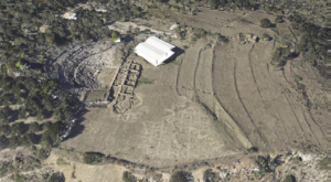
GEOSYSTEMS HELLAS successfully carried out a 3D archaeological mapping and high-resolution aerial surveying project at the archaeological site of Aigeira, Greece, on behalf of the Austrian Archaeological Institute. The project focused on generating accurate, high-resolution geospatial data to support archaeological research, site documentation and the digital preservation of cultural heritage.
Advanced LiDAR Technology and Aerial Mapping
The project combined LiDAR (Light Detection and Ranging) technology with high-resolution aerial photography to create a detailed three-dimensional representation of the archaeological site and its surrounding landscape.
Through the integration of advanced aerial surveying techniques and geospatial data processing, GEOSYSTEMS HELLAS captured detailed information about the area’s terrain, topography, surface characteristics and physical features.
This integrated approach enabled the production of comprehensive 3D geospatial datasets, supporting accurate visualization, spatial analysis and archaeological landscape documentation.
High-Resolution Geospatial Data and 3D Point Clouds
The archaeological mapping project delivered a range of high-accuracy geospatial products, including:
High-resolution orthophotos and orthomosaics, providing detailed aerial representations of the archaeological landscape.
Classified and colorized 3D LiDAR point clouds, enabling detailed terrain visualization and spatial analysis.
5 cm spatial resolution aerial imagery, capturing fine-scale landscape features.
LiDAR point cloud density of 15 points/m², supporting detailed three-dimensional documentation of the surveyed area.
These deliverables provide a reliable digital representation of the archaeological site of Aigeira, facilitating archaeological documentation, terrain analysis, spatial interpretation and future research activities.
Supporting Archaeological Research and Cultural Heritage Preservation
The integration of LiDAR surveying, aerial photogrammetry and 3D geospatial mapping provides valuable tools for understanding, documenting and managing archaeological sites.
By producing accurate digital representations of cultural heritage landscapes, GEOSYSTEMS HELLAS supports archaeological research, enhances the availability of geospatial information and contributes to the long-term digital preservation of cultural heritage.
The Aigeira project demonstrates how advanced geospatial technologies can support archaeological documentation and heritage management through precise, high-resolution spatial data.