

3D Archaeological Mapping and LiDAR Surveying in Greece: Collaboration with the German Archaeological Institute
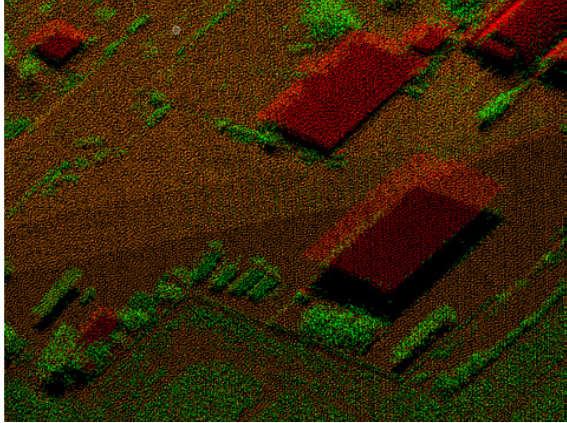
GEOSYSTEMS HELLAS collaborated with the German Archaeological Institute (DAI) on archaeological mapping and cultural heritage documentation activities in Greece, applying advanced LiDAR (Light Detection and Ranging) technology, aerial photography and 3D geospatial data processing.
The collaboration included the 3D mapping of Ancient Tiryns in 2021 and airborne LiDAR surveying in the Kephissos Valley, Phokis, as part of the wider archaeological research program involving the German Archaeological Institute and the Ephorate of Antiquities of Fthiotida and Evrytania.
These activities supported the production of accurate geospatial datasets for archaeological research, topographic analysis and the digital documentation of cultural heritage landscapes.
3D LiDAR Mapping and Aerial Photography of Ancient Tiryns (2021)
In 2021, GEOSYSTEMS HELLAS conducted 3D imaging and aerial surveying of Ancient Tiryns, using LiDAR technology and high-resolution aerial photography to document the archaeological site and its surrounding terrain.
The project involved the generation of high-resolution orthophotos using bare-earth LiDAR data, with additional enhancements through photogrammetric techniques based on stereoscopic aerial imagery where required.
LiDAR point clouds were also enriched with RGB color information derived from the generated orthophotos, producing colorized 3D point clouds suitable for detailed visualization, interpretation and further geospatial analysis.
The combination of airborne LiDAR and aerial photogrammetry enabled detailed mapping of the archaeological landscape, supporting terrain documentation, spatial analysis and cultural heritage research.
Airborne LiDAR Surveying of the Kephissos Valley, Phokis (2018)
As part of the collaborative research program “Topographic Investigations in the Kephissos Valley (Phokis),” conducted by the German Archaeological Institute and the Ephorate of Antiquities of Fthiotida and Evrytania, advanced geospatial surveying technologies were used to support archaeological and landscape investigations.
The broader interdisciplinary program combined archaeological research with aerial imagery, historical aerial photograph analysis, geophysical surveys and geomorphological investigations.
In 2018, an extensive area of approximately 145 km² around Elateia, Tithorea and Modi was surveyed using airborne LiDAR technology and high-resolution RGB aerial imagery. At the time, this represented the largest LiDAR survey coverage of an area in Greece.
The project involved processing LiDAR point clouds to generate a Digital Terrain Model (DTM), which served as the reference surface for orthophoto production across the entire Area of Interest (AOI).
The resulting orthophotos were merged into a comprehensive high-resolution orthomosaic, providing a consistent geospatial representation of the surveyed landscape.
The orthomosaic was subsequently integrated with the LiDAR point clouds to generate RGB-colorized 3D point clouds, combining detailed elevation measurements with visual information from aerial imagery.
High-Resolution Geospatial Deliverables
Across these archaeological mapping activities, the integration of LiDAR and aerial photogrammetry enabled the production of valuable geospatial products, including:
High-resolution orthophotos and orthomosaics for archaeological documentation and spatial analysis.
Digital Terrain Models (DTMs) derived from classified bare-earth LiDAR measurements.
RGB-colorized 3D LiDAR point clouds combining geometric and visual information.
Photogrammetrically enhanced aerial imagery for improved terrain representation and visualization.
Georeferenced spatial datasets supporting archaeological research and landscape interpretation.
Advancing Cultural Heritage Documentation Through Geospatial Technologies
The collaboration with the German Archaeological Institute demonstrates the value of airborne LiDAR scanning, aerial photogrammetry and 3D geospatial mapping in documenting archaeological sites and extensive cultural heritage landscapes.
By integrating high-resolution aerial imagery with LiDAR-derived terrain information, GEOSYSTEMS HELLAS contributed to the creation of detailed digital representations of historically significant areas in Greece.
These geospatial datasets support archaeological research, terrain analysis, historical landscape interpretation and the long-term digital preservation of cultural heritage.
Through the application of advanced remote sensing and geospatial technologies, GEOSYSTEMS HELLAS continues to support the documentation, analysis and sustainable management of archaeological landscapes.
This project is finished